Vector-based terrain modelling

Simon Perche1, Eric Guérin1, Eric Galin2, Adrien Peytavie2
1INSA Lyon, CNRS, LIRIS, UMR5205, F-69621 Villeurbanne, France
2Université Claude Bernard Lyon 1, CNRS, LIRIS, UMR5205, F-69622 Villeurbanne, France

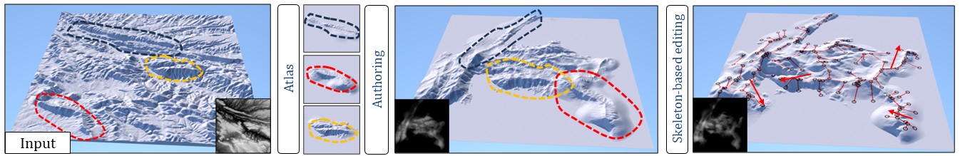
Our framework transforms an input grid-based elevation model into a vector-based representation of ellipsoid-based primitives. Users can interactively edit the vector model using geomorphological skeleton-based tools, as well as standard tools such as stamping, copying, and pasting. The advantage of the vector-based representation is its ability to depict landforms at various levels of resolution while allowing for real-time editing of large-scale terrains.

Abstract

Vector-based graphics offer numerous advantages over grid-based models, including resolution independence and ease of manipulation. Despite these benefits, their use in landscape modeling remains uncommon because of a lack of direct editing and interactive feedback, essential for matching the artist's vision.

We introduce a new vector-based model for creating digital terrains based on computationally efficient primitives. We propose a method to convert grid-based digital elevation maps to this representation with a user-defined level of accuracy.

Once vectorized, the terrain can be authored using interactive high-level skeleton-based tools adapted to the primitive representation, allowing local deformations that automatically adapt to underlying geomorphological structures and landforms of the terrain.

Video

BibTeX


@article{perche2025vectorterrains,
	author  = {Perche, Simon and Guérin, Eric and Galin, Eric and Peytavie, Adrien},
	title   = {Vector-Based Terrain Modelling},
	journal = {Computer Graphics Forum},
	year    = {2025},
}
	

Acknowledgements

This work was part of the project AMPLI ANR-20-CE23-0001 along with the project EOLE ANR-23-CE56-0008, supported by Agence Nationale de la Recherche Française.